It seems like everyone is talking about landscape architecture these days. It has proven itself at tasks that range from the design of public spaces to the organisation of urban development to feats of ecological remediation. As the discipline continues to advance, it appears that landscape architects may soon be able to perform the work of artificial intelligence.
This suggestion may, at first, appear surprising. Artificial intelligence is a diverse field that has produced models, such as ChatGPT or Midjourney, that can seamlessly synthesise technical requirements and creative expression. While AI is a relatively new discipline, it has already developed unique approaches that draw from a varied set of discourses and practices.
Despite these rich complexities, it looks like landscape architects can handily emulate many of the tasks that artificial intelligences perform. This surprising ability stems from the largely unnoticed applicability of one of their design techniques to the machine learning process. It turns out that they have been training all along to perform the linchpin gradient descent algorithm. But, get this, they call it site grading.
While landscape architects can’t — yet — create grading plans that incorporate billions of parameters, understanding the inner workings of grading reveals how they might rethink the way that artificial intelligence work. To unpack this, let’s first step through the gradient descent algorithm that plays a key role in training neural networks:1
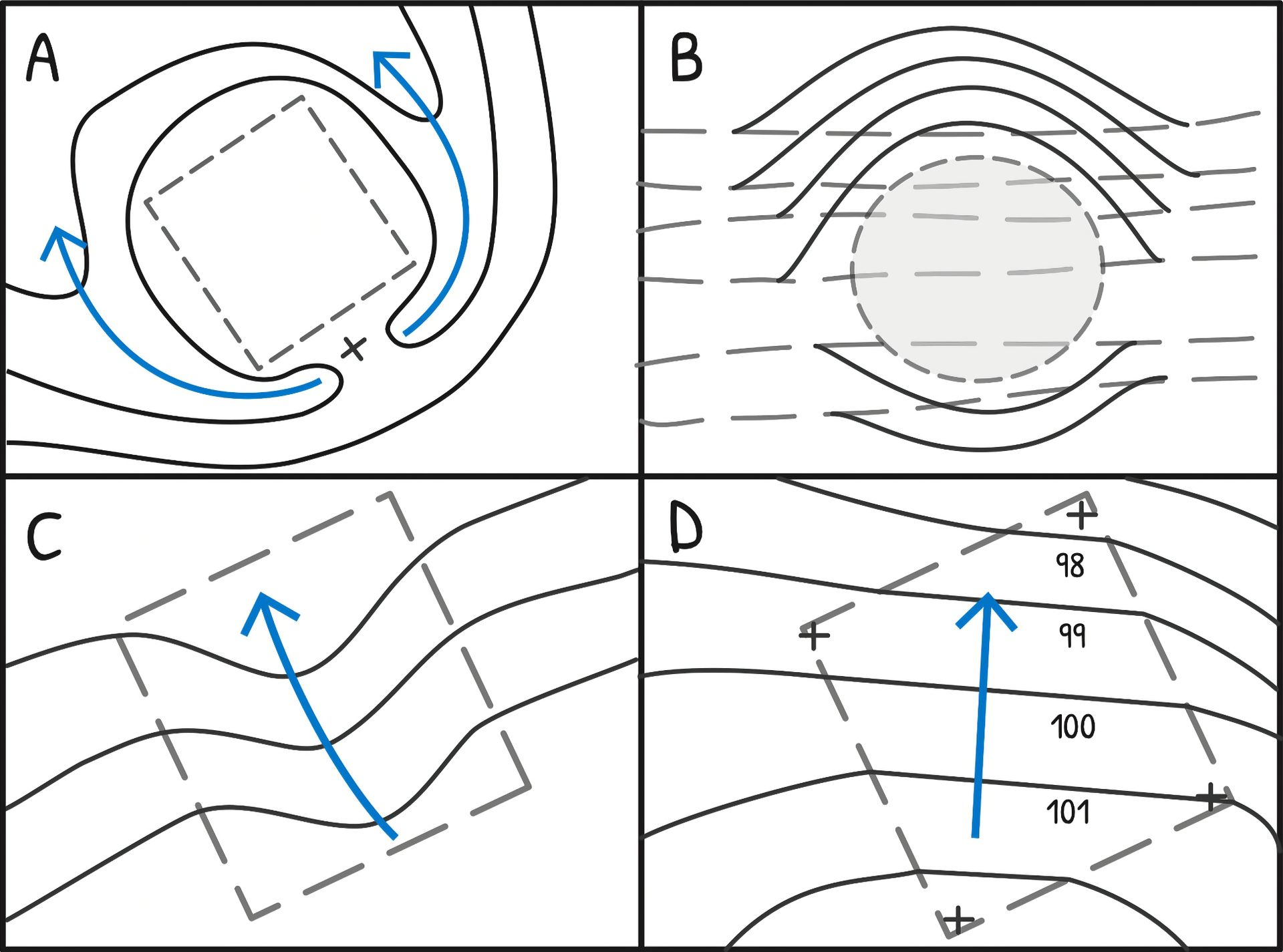
- A virtual terrain encodes the predictive power of different ‘clues’ as spatial coordinates. If an AI is tasked with identifying photographs of elephants, the north-to-south axis of this landscape might measure an increasing weight given to has huge ears as a predictor of ‘elephantness’ while the east-to-west axis does the same for has four legs.
- A point is placed on this pseudo-topographic model. It evaluates the slope directly underneath it, and then moves a short distance in the downhill direction. Because the landform employs the
Zaxis as a register of predictive accuracy, this descending incline points towards areas whoseXYcoordinates encode a more successful admixture of the two clues. - A path forms as the point iteratively re-samples and re-traverses the terrain, descending until it can identify no further downhill direction. The path might terminate within a depressed area to the north: a location wherein has huge ears is an essential clue (large
Yvalue), but has four legs is a mildly-useful hint (moderateXvalue).
Most useful acts of prediction require plenty of clues, so more parameters can be introduced by including additional dimensions atop the standard XY planes. A few billion parameters is usually sufficient to enable AIs to parrot essays or paint with ArtStation pastiche.

Figure .
Figure . An illustration of the gradient descent algorithm (sort of).
So far, so unremarkable. But what landscape architects have discovered is that a very similar approach can also be used to understand landform and determine how water flows across topography — not just direct hyperdimensional vectors within a fitness landscape. At first, it might seem strange that statistical models can be used to understand the geometry or hydrology of real landscapes. But, if you’re willing to step through some technical details, it is a truly fascinating process:2
- A model of an existing, or proposed, terrain is typically represented through a 2D drawing with contour lines that register a landform’s height by way of sections taken at regular vertical intervals.
- This drawing type enables a number of enquiries. For an AI, the most familiar case is when a landscape architect seeks a detailed understanding of how water flows within this landscape. To examine this, they might draw a point on the plan, locate the nearest contour line, identify the contour curve’s tangent, and then take its right angle to determine the direction of water’s downhill travel.
- By extending the point in the downhill direction, and repeating the calculation whenever a new contour is crossed, the water’s path is revealed. As in gradient descent, this path will end when there are no further downhill directions — as indicated by the line of flow crossing the same contour line for a second time.
This end-point identifies places where water may pool; a finding that might suggest an ideal location for a drainage pit or the need for an upstream landform manipulation.

Figure .
Figure . An illustration of some grading considerations at a small scale (left) and a complex grading plan for a large landscape project (right). Diagram by Bruce G. Sharky, plan by Reed Hilderbrand Associates for the Hamilton College Theater and Studio Arts project, with additional annotations. Both from Landscape Site Grading Principles (2015) by Bruce G. Sharky.
Site grading can be a slow and error-prone process, but the task has become more efficient over time. Given this trajectory, and the resource constraints limiting the training of large language models, it may soon make sense for AIs to start outsourcing this part of their workload to landscape architects.
Although the similarities between gradient descent and site grading are remarkable, some may argue that landscape architects might never replace the artistry of traditional machine learning approaches. For example, most grading techniques lack nuance as they largely forgo the ‘hallucinations’ that are core to machine learning’s expressivity. That said, many landscape architects think that the increasing adoption of Revit will soon level the playing field.
The use of landscape architects in machine learning may also present opportunities for better handling authorship practices. The work of AI is often uncredited, or misattributed to collaborators. Many projects pretend that they didn’t work with AI at all! Working with landscape architects will surely help set the record straight.
While the work of artificial intelligence can — at times — appear two-dimensional, learning to delegate to landscape architects will surely introduce some new angles.